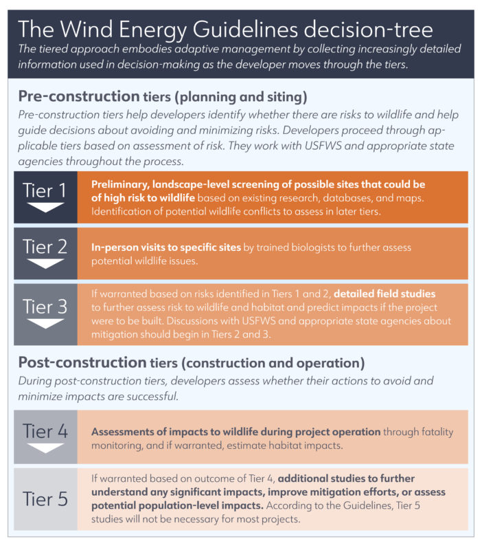
Choosing where to build a solar or wind energy facility is a complex process that can have important implications for impacts to wildlife. In 2012, the U.S. Fish & Wildlife Service (USFWS) released the Land-Based Wind Energy Guidelines to help wind developers avoid and minimize impacts of land-based wind projects on wildlife and their habitats. Informed by discussions among the wind industry, conservation organizations, regulators, and others, these voluntary guidelines are based on a tiered approach to help developers assess and reduce risk to wildlife from construction and operation of a wind energy facility. Many solar developers are applying the risk assessment approach outlined in the Wind Energy Guidelines when siting solar projects.
Tier 1 of the Guidelines informs preliminary assessment of a site being considered for development. In Tier 1, developers use existing research, databases, maps, and other information to identify potential wildlife issues at prospective sites. Tier 1 studies can also identify potential wildlife conflicts to be assessed by professional biologists on-the-ground in Tier 2. For information on the rest of the decision framework from the Guidelines, please refer to the decision tree below.
To conduct preliminary ecological evaluations of a potential site as outlined in Tier 1, developers need access to high-quality wildlife data for the landscape being considered for development. The list below provides examples of several national, regional, and state-level resources for wildlife data that could inform Tier 1 studies.
To learn more about the history and implementation of the Guidelines, please see our Wind-Wildlife Success Story “Wind Energy Guidelines: Science and Collaboration at Work, Every Day,” or review the training materials available on the USFWS website.
National Tools and Resources*
- Threatened & Endangered Species Active Critical Habitat Report (USFWS)
- Information for Planning and Consultation (IPaC)
- National Wetlands Inventory (USFWS)
- Data Basin (Conservation Biology Institute)
- eBird (Cornell Lab of Ornithology)
- National Gap Analysis Project (USGS)
- U.S. Large-Scale Solar Photovoltaic Database (USGS)
- GenEst – A Generalized Estimator of Mortality (USGS)
- Google Earth
- Information for Planning and Consultation (USFWS)
- LandScope America (Nature Serve and National Geographic)
- National Wetlands Inventory (USFWS)
- National Gap Analysis Project (U.S. Geological Survey)
- NEPAssist (U.S. Environmental Protection Agency)
- TNC Interactive Conservation Maps (The Nature Conservancy)
- Tribal Directory Assessment Tool (U.S. Departmet of Housing and Urban Development)
- ReMOTe – Remote Marine and Onshore Technology (Normandeau)
- Guide to North American Birds (Audubon)
- TETHYS Wind Energy Monitoring and Mitigation Technologies Tool (PNNL/DOE)
- TETHYS Map Viewer Wind Energy (PNNL/DOE)
- NREL Software Catalog (NREL)
- NREL Data and Tools Catalog (NREL)
- Community Solar Scenario Tool (NREL)
- CREST: Cost of Renewable Energy Spreadsheet Tool (NREL)
- State of Bats: Conservation Status and Threats to North American Bats (Bat Conservation International)
Region-Specific Tools and Resources*
- Site Wind Right (The Nature Conservancy)
- Southern Plains Wind and Wildlife Planner (Playa Lakes Joint Venture)
- Crucial Habitat Asessment Tool (Western Association of Fish & Wildlife Agencies)
- Crucual Habitat Assessment Tool (State of Alaska)
- HabiMap Arizona (Arizona Game & Fish)
- Areas of Conservation Emphasis (ACE 3) (California Department of Fish & Wildlife)
- Threatened and Endangered Species by County (Kansas Department of Wildlife & Parks)
- Long Island Solar RoadMap (The Nature Conservancy)
- Species by County (Nebraska NRCS)
- Environmental Review List (Pennsylvania Natural Heritage Program)
- Rare, Threatened, and Endangered Species by County (Texas Parks & Wildlife)
- Priority Habitats and Species (Washington Department of Fish & Wildlife)
- Virginia Natural Heritage Data Explorer (Virginia Department of Conservation and Recreation)
- State Wildlife Action Plans (SWAP) (USGS)
- RaptorMapper (Teton Raptor Center)
State-Specific Tools and Resources*
- AFWA State Mechanisms for Supporting Low-Impact Solar Siting
- Alaska Fish Resource Monitor
- Arizona HabiMap™
- California Areas of Conservation Emphasis (ACE-II)
- Montana Crucial Areas Assessment and Planning System (CAPS)
- Environmental Resource Mapper (New York State)
- Kansas Natural Resource Planner
- Kansas Threatened & Endangered Species by County
- Michigan Natural Features Inventory
- Montana Crucial Areas Assessment and Planning System (CAPS)
- Natural Heritage New Mexico
- Nebraska NRCS Species By County
- North Dakota GIS Hub Data Portal
- Pennsylvania Natural Heritage Program
- Rare, Threatened, and Endangered Species of Texas by County (Texas Parks & Wildlife)
- State Wildlife Action Plans
- Virginia Natural Heritage Data Explorer
- Washington Priority Habitats and Species
*Note: these tools and resources are provided as examples, and these lists are not intended to be comprehensive. If you have suggestions for other examples, please contact info@rewi.org.